This site is intended to provide you with information on a Land Surveying Company in Lafayette, AL. If you’re looking for a Lafayette Land Surveyor, you’ve come to the right site. If you’d rather talk to someone about your land surveying needs, please call (334) 234 9946 today. For more information, please continue to read.
Land Surveyors are professionals who measure and make precise measurements to determine the size and boundaries of a piece of real estate. While this is a simplistic definition, boundary surveying is one of the most common types of surveying related to home and land owners. If you fall into the following categories, please click on the appropriate link for more information on that subject:
Lafayette Land Surveying services:
I need to know where my property corners or property lines are. (Boundary Survey)
I have a loan closing or re-finance coming up on a commercial property or multi-family property and need an ALTA Survey. (ALTA Survey)
I need a map of my property with contour lines to show elevation differences for my architect or engineer. (Topo Survey)
I’ve just been told I’m in a flood zone or I ‘ve been told I need an elevation certificate in order to obtain flood insurance or prove I don’t need it. (Flood Survey)
I’m purchasing a larger tract of land, acreage, that hasn’t been subdivided in the past. (Boundary Survey)
If your needs don’t fall into one of the above, don’t worry, we’ll get to the bottom of it. CALL Lafayette Land Surveying TODAY at (334) 234 9946 OR better yet, fill out a Contact Form request to discuss your survey needs.
Many commercial properties do not stand alone. They share parking lots, driveways, and entry points with neighboring buildings. An ALTA Title Surveygives exact details about these shared spaces, showing exactly where boundaries lie and how common areas are used. This document clears up confusion, so owners, buyers, and lenders understand exactly what they are dealing with before any deal or project moves forward.
Understanding How Neighboring Businesses Depend on the Same Spaces
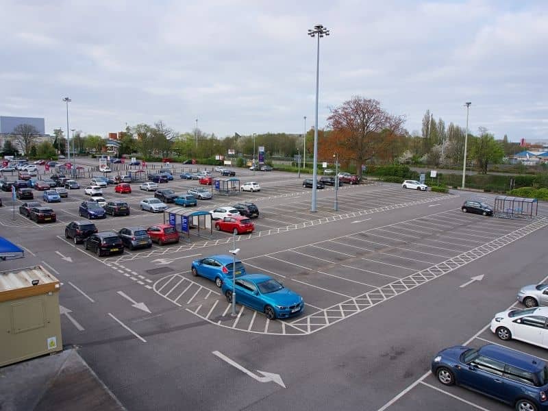
In many shopping centers, office parks, or mixed-use areas, several businesses sit close together. They do not each have their own separate road or full parking lot. Instead, they use driveways, lanes, and parking spots that serve everyone at once. These shared areas become the main way customers and workers reach each building.
When one business changes how it operates, it affects all the others nearby. If parking feels too crowded or if entry points are hard to find, every tenant sees fewer visitors. An ALTA Title Survey maps these shared spaces clearly, so everyone sees how they connect and rely on one another. It helps owners see that their property works as part of a larger whole.
Here are common shared features shown in these surveys:
Main access roads and connecting drive lanes
Parking areas used by more than one property
Walkways leading to entrances and exits
Curbs, gutters, and traffic markings that guide movement
Vehicles and people do not move in straight lines that stop at property lines. They follow paths that feel natural and easy to use. Customers turn into the main drive, look for a spot, and walk toward the door. Delivery trucks follow wider lanes to reach loading zones. Even employees use the same routes day after day.
If these paths are not clearly marked or understood, problems happen. Cars may block each other, or people may walk in unsafe areas. An ALTA Title Survey shows exactly how these routes run across the entire site. It reveals how traffic moves from the street into parking areas and toward each building. This information helps everyone see how the whole area functions, not just one piece of it.
Evaluating How Multiple Property Users Influence Site Functionality
Different types of businesses bring different needs to the same space. A restaurant gets busy at lunch and dinner, while an office sees most visitors during work hours. A retail store may stay open late, and a service shop might have large trucks coming and going all day. All of these groups use the same parking and driveways.
When you combine these patterns, the same space can feel quiet in the morning and full in the afternoon. If one business expands its hours or adds more staff, it changes how crowded the lot becomes. An ALTA Title Survey shows the full layout, so owners can see how changes to one use will affect everyone else. It gives a clear picture of how the site works under normal and busy conditions.
Looking at Commercial Sites as Connected Environments Instead of Separate Parcels
At first glance, each building looks like its own separate property. Legal records list them as different lots, and different people or companies may own them. But once you look closer, you see they operate as one connected area. The same driveway leads to all of them, and the same parking spots serve every customer.
Treating them as completely separate can lead to mistakes. Someone might plan to close off a section of pavement, not realizing it is the only way for neighbors to reach their own doors. An ALTA Title Survey shows where one lot ends and another begins, but also shows how the shared areas cross those lines. It helps everyone see the whole picture, not just their own piece of land.
Supporting Future Transactions Through a Clear Understanding of Shared Features
When someone buys or finances a commercial property, they need to know exactly what rights come with it. This is extra important when parking and access are shared. The new owner must understand how much space they can use, what rules apply, and how they work with neighbors.
An ALTA Title Survey provides all these details in one clear document. It shows the location of every shared feature, marks any legal agreements about their use, and notes any limits or restrictions. This clarity makes buying or selling easier and faster. It reduces surprises later, so decisions are based on facts instead of guesswork.
Frequently Asked Questions
Why do some commercial properties rely on shared parking areas?
Sharing space saves money and makes better use of land. Instead of building separate lots and driveways for every business, owners create one large area that serves everyone. This arrangement keeps costs lower and leaves more room for buildings and green space.
Which types of businesses commonly share access drives and parking facilities?
Retail stores, restaurants, offices, banks, and service shops often group together. They work well in clusters because they draw different customers at different times. This way, the parking lot stays busy but rarely feels full all day long.
Does customer traffic influence the way commercial sites function?
Yes, it changes how the space feels and works. When many people arrive at once, drive lanes and parking areas must be wide enough and well arranged. If the layout is confusing or too tight, visitors will leave or have trouble moving around.
Are commercial properties always completely independent from neighboring parcels?
No, many are linked through shared features. Even if owned separately, they often depend on the same roads, parking, and walkways. What happens on one lot affects how well the next one works.
What role does an ALTA Title Survey play when properties contain shared site features?
It creates a clear, legal record of boundaries and common areas. It shows exactly where shared spaces lie and how they may be used. This information protects owners, helps with planning, and keeps future transactions smooth and clear.
Title insurance protects you from legal claims tied to a property’s ownership history, such as unpaid debts, past fraud, or errors in old records. A land survey measures the property and shows what is on the ground today. They protect against different problems. Having one does not replace the need for the other.
When you buy a home or a piece of land, two services work to protect you: title insurance and a land survey. A lot of buyers think these two things do the same job. They do not. Knowing what each one covers can save you from a costly surprise after you close.
What Title Insurance Covers
Title insurance covers financial losses from problems in a property’s ownership history. These include unpaid debts, forged documents, mistakes in old records, and claims from people who say they own part of the property. It only covers things that happened before you bought the property, not physical issues with the land itself.
Every property has a history. It may have changed hands dozens of times over the years. Along the way, problems can be buried in the records. Title insurance is designed to protect you if those problems show up after you buy.
Here are some common things title insurance can cover:
Unpaid taxes or contractor bills left behind by a previous owner
Forged signatures on old deeds or transfer paperwork
Mistakes in county records that affect who legally owns the property
Claims from heirs of a past owner who say they were never included in the sale
According to ALTA, title companies paid out over $600 million in claims in 2022. The most common causes were unpaid debts, recording errors, and fraud. Title insurance is built to handle exactly those kinds of problems.
Title insurance is a one-time cost paid at closing. There are no monthly or yearly fees after that. The average cost for owner’s coverage in the U.S. is about $1,000, though it depends on where you live and the price of the property.
What a Land Survey Covers
A land survey shows the physical facts about a property. A licensed surveyor visits the land, takes measurements, and produces a document showing exactly where the boundary lines are and what is on the property today. It captures what is true right now on the ground, which records and paperwork cannot show.
While title insurance looks back through history, a land survey looks at what is real and present. A surveyor goes to the property, measures it carefully, and creates a certified document with the findings.
A survey can uncover:
The exact location of boundary lines based on legal records and physical measurements
Fences or structures that cross into a neighbor’s land, or vice versa
Utility lines running through the property
Differences between what the deed says and what actually exists on the ground
Old survey markers left by previous surveyors
A survey does not offer insurance. What it gives you is a clear, factual picture of what you are buying. No title policy can do that.
The Survey Exception: The Gap Most Buyers Miss
Most standard title insurance policies have a survey exception. This is a clause that says the policy will not cover losses that a current survey would have found. So if a boundary problem or a structure crossing a property line is discovered after closing, your title insurance will likely not pay for it.
This is one of the most important things to understand about title insurance and surveys.
The survey exception is written into most standard title policies. It protects the title company, not you. If a problem exists on the ground that a surveyor would have caught, the insurance company can use this clause to deny your claim.
Here is a simple example. Say the previous owner built a retaining wall that crosses two feet into the neighbor’s property. A search of ownership records will not show this because it is a physical problem, not a paperwork problem. A land survey would find it. If you skip the survey and buy the property, then the neighbor demands the wall be moved, your title policy will almost certainly not cover the cost.
Some buyers can have this exception removed. If you give the title company a current, certified survey, they may be willing to issue a policy that covers boundary and encroachment issues. This is called extended coverage, and it is worth asking about when reviewing your policy options.
How the Two Work Together
Title insurance and a land survey protect you in different ways. One covers the past. The other covers the present.
Title Insurance
Land Survey
What it covers
Ownership history, debts, fraud, recording errors
Physical boundaries, encroachments, markers
When it applies
Problems that existed before your purchase
Conditions on the ground today
Who provides it
Title insurance company
Licensed land surveyor
How it is paid
One-time fee at closing
One-time professional service fee
Does it expire
No
No, but lenders may require updates over time
Can one replace the other
No
No
Nearly all mortgage lenders require lender’s title insurance before approving a loan, according to the CFPB. This policy protects the lender, not you. Owner’s title insurance is a separate product that protects your investment directly. It is optional in most states, but strongly recommended.
When you have both a current survey and owner’s title insurance, you are covered from two different directions. That is the strongest position to be in before closing.
Know What You Are Getting Before You Close
A title search helps identify previous ownership records and any legal claims connected to a property. A survey shows the physical layout of the land, including boundary lines, easements, and visible improvements. Together, these documents help clarify both the legal and physical condition of a property before closing.
Boundary surveys and ALTA surveys are commonly used in residential and commercial real estate transactions to verify property details and support the closing process.
Frequently Asked Questions
Can I skip the survey if I have title insurance?
No. Title insurance does not cover physical boundary problems. Without a survey, you have no way of knowing whether the property matches what the deed describes. The survey exception in your policy means those physical problems are your responsibility.
What is ALTA extended coverage?
It is an upgraded title policy that removes the survey exception. It adds protection against encroachments and boundary disputes. To get it, your title company will usually require a current ALTA/NSPS survey that meets national standards.
Who orders the title insurance and the survey?
Title insurance is arranged through the title company or closing attorney. The survey is a separate order placed by the buyer, the lender, or both. They are handled independently and can be done at the same time.
Does my lender’s title insurance protect me?
No. Lender’s title insurance only protects the bank or lender. It does nothing for you as the buyer. Owner’s title insurance is a separate policy that covers your financial interest in the property.
A standard residential land survey takes one to two weeks from the time you hire a surveyor to the day you receive the final certified report. Fieldwork on a typical residential lot takes one to two days. Research and drafting fill the rest of the timeline. Complex properties or busy seasons can push delivery to three weeks or more.
If you are working toward a closing date or a construction start, knowing the survey timeline in advance can save you a lot of stress. A survey that takes longer than expected is one of the more common reasons closings get pushed back. This guide walks you through each phase so you know exactly what to expect.
The Three Phases of a Land Survey
Every land survey goes through three phases: research, fieldwork, and drafting. Each phase takes a different amount of time, and each one can be affected by factors specific to your property. Understanding all three helps you set a realistic schedule from the start.
A land survey is not just a person walking around your yard with equipment. There is significant work that happens before and after the field visit. Here is how the three phases break down.
Phase 1: Research (One to Two Days)
Before a surveyor visits your property, they research its legal history. This includes reviewing the recorded deed, locating the original plat, and identifying any easements on file with the county.
If the property has a clean and well-documented history, this phase moves quickly. If records are incomplete or the property has changed hands many times, research can stretch to two full days. According to the American Congress on Surveying and Mapping, deed research alone can range from two hours to two full days depending on the quality of local records.
Phase 2: Fieldwork (Two Hours to Two Days)
This is the part most people picture when they think of a survey. The surveyor visits the property, locates existing monuments or markers, takes precise measurements of the boundaries, and documents what is found on the ground.
For a standard suburban lot, fieldwork takes two to eight hours. Larger properties, wooded land, irregular shapes, and challenging terrain all add time. A rural property with no existing monuments could require a full day or more in the field.
Phase 3: Drafting and Review (Two to Five Business Days)
Once fieldwork is complete, the surveyor compiles measurements, creates the final plat, writes the legal description, and reviews the work before signing and sealing the document. The NSPS notes that this phase typically adds two to five business days to the total timeline.
What the Total Timeline Looks Like
For a straightforward residential boundary survey, here is a realistic timeline from first contact to final delivery:
Stage
Typical Time
Scheduling and intake
Same day to two business days
Records research
One to two days
Fieldwork
Two hours to two days
Drafting and review
Two to five business days
Total
One to three weeks
Most clients in the Lafayette area can expect to receive their certified report within one to two weeks of placing their order, assuming no complications arise with the property history or field conditions.
What Can Slow a Survey Down
Even a simple survey can take longer than expected when certain conditions come into play.
High Demand Seasons
Real estate transactions in the U.S. peak between April and August each year. During this window, surveying firms in active markets often carry backlogs of two to four weeks. Outside of peak season, the same firm might deliver results in three to seven days. Scheduling your survey right after going under contract gives you the best chance of avoiding a delay at closing.
Incomplete County Records
Older properties and rural parcels are most vulnerable to this issue. If the legal description in the deed is vague or references landmarks that no longer exist, the surveyor must spend more time tracing the ownership history and reconciling conflicting documents. This is common in areas where land has not been formally surveyed in decades.
Weather Conditions
Fieldwork requires accurate physical measurement. Heavy rain, standing water, dense fog, or frozen ground can make conditions unsafe or inaccurate. When weather delays fieldwork, the entire timeline shifts. This is more common in winter or in flood-prone areas.
Property Access Issues
If a property has locked gates, restricted access, or portions that require permission from a third party to enter, scheduling the field visit may take longer. Surveyors cannot legally enter adjoining properties without permission, which can occasionally affect how quickly boundary work is completed.
How to Plan Around a Closing Date
If you are working toward a specific closing date, here is how to manage the survey timeline without putting that date at risk.
Order the survey immediately after going under contract. Do not wait for the inspection or financing approval to come back first. Those processes run in parallel and will not be affected by the survey. Every day you wait is a day off your timeline.
Tell the surveyor your deadline upfront. A good surveyor will tell you right away whether your deadline is achievable with standard service or whether you need expedited processing. Having that conversation on day one is far better than discovering a problem in the final week before closing.
Build in a buffer. Unexpected research issues, a weather delay, or a busy week at the firm can each add a few days. If your closing is three weeks out, ordering the survey today gives you a reasonable buffer. Ordering it in week two does not.
Confirm deliverable requirements with your lender early. Some lenders require a signed and sealed plat. Others accept a survey affidavit or a digital copy. Knowing the exact format your lender needs prevents a last-minute revision that costs time you cannot afford to lose.
Frequently Asked Questions
Can a land survey be completed in one day?
The fieldwork can sometimes be done in a single day for a small, uncomplicated property. However, the full process including research, drafting, and review almost always takes longer. A signed, certified report is rarely ready the same day fieldwork is completed.
Does the time of year affect how long a survey takes?
Yes. Spring and summer are peak seasons for real estate and construction, which means higher demand and longer wait times. Scheduling during fall or winter typically results in faster turnaround, though weather can sometimes offset that advantage.
Will I be notified when the survey is complete?
Most firms contact the client directly when the report is ready. Ask at the time of scheduling how delivery works, whether you will receive a digital copy, a physical plat, or both, and who else needs a copy such as your lender or title company.